
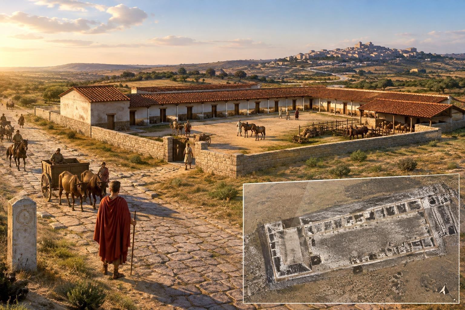
For a traveller crossing Roman Hispania, a long journey was measured not only in miles but in places to stop: to rest, tend animals, or change transport. Near the ancient town of Mellaria in southern Spain, archaeologists have now detected a large building that may have served just such a purpose. Its plan is strikingly practical—but its exact role remains unproven.
Researchers from the University of Córdoba found the structure near modern Fuente Obejuna, outside the Roman settlement. It stretches about 48 metres and covers roughly 1,290 square metres. The discovery, reported in the Journal of Archaeological Science: Reports, offers a rare chance to examine the infrastructure that supported movement across the Iberian Peninsula.
A building laid out for movement
The team did not uncover the building by digging. Instead, a cart-mounted system carrying four magnetic gradiometers measured small variations in the Earth’s magnetic field. Those variations can reveal buried walls and other features, allowing archaeologists to map a structure while leaving it undisturbed.
The resulting plan shows a rectangular complex divided into a repeated sequence of rooms, alongside a substantial open area. Eight rooms appear to be similar in size, each about 3.6 by 4 metres. Such regularity suggests deliberate planning, though a magnetic survey cannot tell researchers what happened in each room.
At the western end is a larger room, about 44.8 square metres. Its size resembles bathing spaces identified at a Roman roadside station in Rottweil, Germany, but that comparison is a clue, not an identification: the room’s function at Mellaria is unknown. An open space about 11 metres wide may have accommodated animals, vehicles or stored goods.
Researchers see a resemblance between the arrangement and Roman mansiones—official stopping places along important roads. Such facilities could offer lodging and practical support to authorised travellers, including officials and military personnel. The Mellaria building may fit that pattern, but its status has not been confirmed, and its simple layout does not reveal who used it.
At the crossroads of two provinces
Mellaria stood beside a major road linking Corduba, capital of Baetica, with Emerita Augusta, capital of Lusitania. The route appears as Route XI in the Antonine Itinerary, an ancient compilation of Roman roads and distances. That text places Mellaria 52 Roman miles from Corduba.
The settlement began as a military establishment around the middle of the second century BC and later developed into a town associated with mining, metalworking and agriculture. Its position on the road connected local production and communities to two important centres. For Rome, roads were not simply lines between cities: they helped move people, goods and official communications across a vast territory.
A station at Mellaria could have been connected with the cursus publicus, the empire’s official transport and communications system. But proximity to a major road does not prove that a building belonged to that network. The term mansio is a useful comparison for the plan; it is not yet a settled label for this particular site.
What the survey cannot tell us
Geophysical methods are powerful precisely because they can reveal a buried layout without excavation. They can show where walls and open spaces may lie, but they do not provide the objects, construction layers or other evidence needed to establish a precise date and confirm how rooms were used. The Mellaria survey therefore presents a strong architectural outline, not a complete biography of the building.
Other anomalies detected nearby may point to additional buried structures, perhaps part of a larger complex. Roadside facilities elsewhere could include stables, workshops, storage or bathing areas, but none of those features can yet be assigned to Mellaria on the evidence described so far. Further investigation would be needed to test that possibility.
For now, the most revealing discovery is the building’s arrangement: repeated rooms beside a broad working space, set just beyond a town on a major route. It hints at the everyday logistics behind Roman travel—the unglamorous places that made long-distance movement possible. The walls remain underground, but their plan invites a question as old as the road itself: who stopped here, and what were they carrying onward?